Robert B. Case, PhD, PE
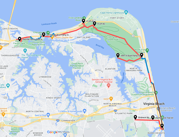
Experience the beauty of Chesapeake Bay, the nature of First Landing State Park, and the fun of the Virginia Beach oceanfront by biking (or jogging) on a system of trails that connects the Bay to the Ocean.
 |
Legend: path, low-volume road, boardwalk and bike path (parallel to each other) |
As shown on the above map, you can access this system of trails by car at any of the following parking areas:
- Bayville Farms Park 4132 First Cut Rd
- Lynnhaven Boat Ramp & Beach Facility 3576 Piedmont Cir
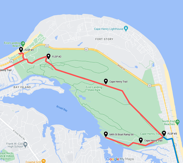
- First Landing State Park (FLSP) lot #1 2500 Shore Dr
- First Landing State Park (FLSP) lot #2 Trail Center, Cypress Swamp Dr
- First Landing State Park (FLSP) lot #3 64th St
- 64th St Boat Ramp lot 64th St
- Rudee Loop lot 104 Atlantic Ave
- Norfolk Ave Trail lot 609 Norfolk Ave
Today, let’s ride these trails west-to-east from Bayville Farms Park to Birdneck Road, a total of 15 miles:
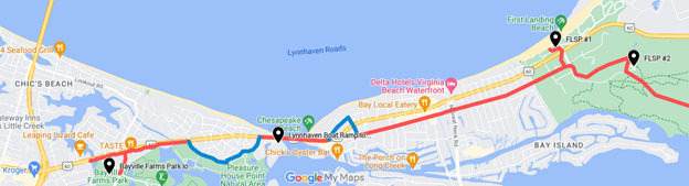
The first segment of this bay-to-ocean route runs roughly parallel to Shore Drive from Bayville Farms Park to First Landing State Park (FLSP) parking lot #2, a distance of 5 miles, as shown below.
 |
Legend: path, low-volume road |
This first 5-mile segment is described in two parts below:
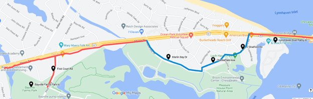
From Bayville Farms (as shown on the map below):
- follow the path along First Court Rd to Shore Dr
- follow the path along Shore Drive to Marlin Bay Dr
- follow low-traffic-volume roads Marlin Bay Dr, Chesterfield Ave, and E Stratford Rd back to Shore Dr
- cross Shore Drive at the traffic signal, then follow the path across Lesner Bridge.
 |
Legend: path, low-volume road |
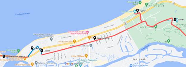
From Lesner Bridge (as shown on the map below) follow low-traffic-volume roads Page Ave and Jade St to Shore Drive, cross Shore Dr at the traffic light, follow Jade St to the Cape Henry Trail, and follow that trail to the First Landing State Park (FLSP) parking lot #2.
 |
Legend: path, low-volume road |
The second segment of this bay-to-ocean route runs through First Landing State Park (FLSP). From FLSP parking lot #2 (as shown on the map below), follow the Cape Henry Trail to FLSP parking lot #3 (a distance of 3.5 miles) and/or the 64th St Boat Ramp and the Narrows—where Broad Bay becomes narrow—near the ramp (an additional 1.5 miles).
 |
Legend: path, low-volume road |
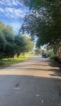
The surface of the Cape Henry Trail varies (as shown below):
- from Jade St to FLSP lot #2, the trail is paved
- from FLSP lot #2 to FLSP lot #3 to 64th St Boat Ramp, the trail has a natural surface.
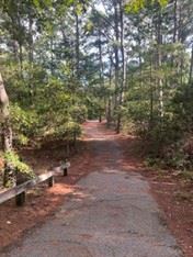 | 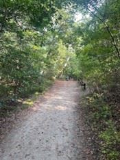 |
Cape Henry Trail- paved portion | Cape Henry Trail- unpaved portion |
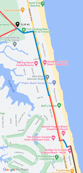
The third segment of this bay-to-ocean route runs along Atlantic Ave. From First Landing State Park (FLSP) parking lot #3 (as shown on the map below):
- follow the low-traffic-volume 64th St to Atlantic Ave
- follow the low-traffic-volume feeder road along Atlantic Ave to 50th St (photo below)
- follow the concrete path (photo below) along Atlantic Ave to the paved plaza fronting the Grand Lawn of Cavalier Hotel
The third segment totals 2 miles.
 |
Legend: path, low-volume road, boardwalk and bike path (parallel to each other) |
 | 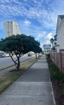 |
Feeder road parallel to Atlantic Ave | Concrete path parallel to Atlantic Ave |
The fourth segment of this bay-to-ocean route runs along Atlantic Ocean. From the paved plaza fronting the Grand Lawn of Cavalier Hotel:
- cross the highway and follow the sidewalk over to the cul-de-sac of the commercial portion of Atlantic Ave (blue line on map below)
- follow this low-traffic-volume dead-end block of Atlantic Ave to 40th St
- follow 40th St to the boardwalk (photo) and parallel bike path
- follow the boardwalk (serving cyclists and pedestrians) or bike path (serving cyclists) to its end at Rudee Inlet (photo).
The fourth segment totals 3 miles.
 |
Legend: path, low-volume road, boardwalk and bike path (parallel to each other) |
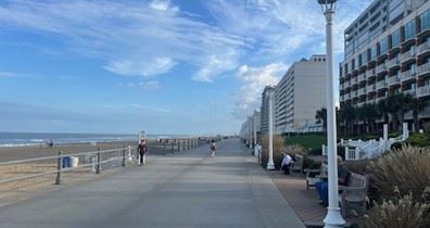 | 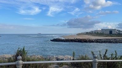 |
Va. Beach Boardwalk | Rudee Inlet |
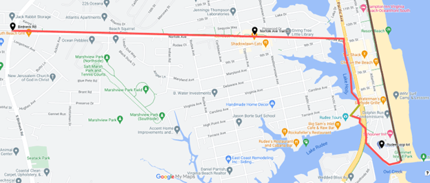
The fifth segment of this bay-to-ocean route runs inland to Birdneck Road. From the southern end of the boardwalk or oceanfront bike path:
- follow the concrete path underneath Pacific Ave to Winston Salem Ave
- follow the Winston Salem Ave sidewalk almost to Pacific Ave
- follow the elevated trail across Lake Holly (known as Old Beach Trail) to Norfolk Ave
- follow the Norfolk Ave Trail along Norfolk Ave to Birdneck Rd.
The fifth segment totals 2 miles. The total length of all five segments—from Bayville Farms Park to Birdneck Rd—is 15 miles.
 |
Legend: path, sidewalk, boardwalk and bike path (parallel to each other) |
Note that the City of Virginia Beach promotes a tour on trails—including many of the above segments—called the “Bike, Brews & History Tour” (BBHT), details of which can be found via this link:
https://assets.simpleviewinc.com/simpleview/image/upload/v1/clients/virginiabeachva/VBBT_Bike_Brew_History_EN_8f4f94e5-cddc-42aa-b164-4f8627583085.pdf
Whichever segments you choose, enjoy the ride!